Along the route of US 322 in Juniata County, PA is a roadcut that exposes a neat fold in the rocks. It's called the Lewistown Narrows and is near the town of Macedonia. The project, started in 2004 and completed four years later, was designed to build a four lane section of road to replace the aging, crowded and dangerous (it was once in the top ten most dangerous sections of roadway in the nation) original two lane road. As part of the project a new cut through what is essentially the toe of Blue Mountain was made. This exposed a beautiful layer cake of the Turscarora formation with a little bit of Rose Hill formation on the side.
Here is a view of the western end of the cut. Remember to click on the picture to see the full view.
And here is a view of the center of the cut with beautiful stair step folds..
This is a closer view of the easternmost portion of the cut. The folding here is a little more complex.
The last pic shows some of the Tuscarora formation and the start of the Rose Hill formation. The Rose Hill formation is an olive to brown colored shale with thin beds of red to brown sandstone.
This is a geologic map view of the Narrows that I created with Google Earth and overlay files from the USGS website HERE. It looks as though the cut should be through a typical arch shaped anticline (the Blue Mountain anticline) but in reality it is not that simple .
Here is the same map but with the formations noted.
A regional view provides an even more complex picture. The thumbtack is the Lewistown Narrows. This area is right in the middle of the "bend" in the Appalachian mountains where the somewhat east to west trend turns and heads south-southwest.
This portion of the state is very tightly folded and you can see how the Juniata river follows the valley between the two ridges.
As for fossils, you can find some in the Rose Hill formation but the Tuscarora formation is fairly barren. The only fossils I've found in it are trace fossils like the Paleophycus below.
Paleophycus is a type of burrow that has been ascribed to a worm and is only found in the gray shaly layers between the white to tan colored sandstone layers. The sandstone likely represents a beach environment with the shale layers being temporary mud flats that formed as the sea level fluctuated.
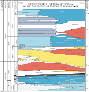
The Tuscarora and Rose Hill formations are Silurian in age and range from the Llandovery to Wenlock epochs (Telychian to Sheinwoodian stages). The particular moment in time that this cut represents is the very latest Telychian stage. Below is a stratigraphic chart from the PA Geological Survey website HERE.
In comparison to other Silurian localities I've collected at, the Waldron Shale is about the same age as the Rochester shale of New York and they are considered to be Sheinwoodian in age; The Irondequoit limestone underlies the Rochester shale and is just above the Rose Hill shales in the Sheinwoodian stage; The Keyser formation is at the very top of the Silurian grading into the Devonian.


Cool fossils!
ReplyDelete