Showing posts with label Geology. Show all posts

Friday, August 10, 2012

Germany Valley overlook

This past April I took a trip through Virginia and West Virginia exploring some sites that were listed in the book "Fossil Collecting in the Mid-Atlantic States" by Jasper Burns. In my previous post I showed you some fossils from a roadcut into the Reedsville formation. Across from that roadcut, where I parked my car, is a pull off for an overlook of the Germany Valley. Below is a panorama of the view looking north with east to the right.


I found this view to be both peaceful and intriguing as it shows a couple of classic geologic features. The first thing I noticed was that the ridge line on the east side seemed to have, at one time, crossed the valley and dipped down. This meant that I was looking at an Anticline which is an "A" shaped fold of rocks which, in this case, was folded in an east-west direction. Not only was this an anticline but much of the rock had been eroded out of the middle and so it could be called a breached anticline. Something else I noticed about the geology was that this was a plunging anticline meaning the folded rock was bent again in another direction (this time north to south) like a dolphins back rising out of the water. Lets look at this from a higher angle with a Google earth map that has the topography exaggerated to better see the ridge lines.


And this is my interpretation of  how the fold would have looked prior to the breach and erosion of the center.


Note that you can see at the north end of the valley how the valley closes in on itself and the ridgelines meet. This is the evidence for the plunging anticline. Below is a geologic map of the valley from Google Earth. I've picked out the two resistant rock layers that are the cause for the ridges; the Juniata formation and the Tuscarora formation. Both are hard sandstones that resist weathering more than the softer shales and limestones that make up the valley. You can see by the colors distinguishing different layers that the rocks are folded and repeat on each side of the valley.


Here is an excerpt from this James Madison University field trip guide to the same location:
At the overlook you can observe Germany Valley (Ordovician limestones at the culmination of the Wills Mountain anticline); the ridge crest of North Fork Mountain (Tuscarora Sandstone on the east limb of Wills Mountain anticline) to the east; and River Knobs (Tuscarora Sandstone on the west limb of Wills Mountain anticline), which also form the first set of "razorback" hills or ridges to the west. At the northeast end of Germany Valley the Tuscarora ridge forms a spectacular example of closure at the nose of the plunging anticline.

Once you've taken in the scenery and geology of the view there are a couple of signs which tell of some historical events that occurred in the valley.


Monday, April 16, 2012

Lewistown Narrows roadcut

Along the route of US 322 in Juniata County, PA is a roadcut that exposes a neat fold in the rocks. It's called the Lewistown Narrows and is near the town of Macedonia. The project, started in 2004 and completed four years later, was designed to build a four lane section of road to replace the aging, crowded and dangerous (it was once in the top ten most dangerous sections of roadway in the nation) original two lane road. As part of the project a new cut through what is essentially the toe of Blue Mountain was made. This exposed a beautiful layer cake of the Turscarora formation with a little bit of Rose Hill formation on the side.

Here is a view of the western end of the cut. Remember to click on the picture to see the full view.


And here is a view of the center of the cut with beautiful stair step folds..


This is a closer view of the easternmost portion of the cut. The folding here is a little more complex.


The last pic shows some of the Tuscarora formation and the start of the Rose Hill formation. The Rose Hill formation is an olive to brown colored shale with thin beds of red to brown sandstone.

This is a geologic map view of the Narrows that I created with Google Earth and overlay files from the USGS website HERE. It looks as though the cut should be through a typical arch shaped anticline (the Blue Mountain anticline) but in reality it is not that simple .


Here is the same map but with the formations noted.


A regional view provides an even more complex picture. The thumbtack is the Lewistown Narrows. This area is right in the middle of the "bend" in the Appalachian mountains where the somewhat east to west trend turns and heads south-southwest.


This portion of the state is very tightly folded and you can see how the Juniata river follows the valley between the two ridges.

As for fossils, you can find some in the Rose Hill formation but the Tuscarora formation is fairly barren. The only fossils I've found in it are trace fossils like the Paleophycus below.


Paleophycus is a type of burrow that has been ascribed to a worm and is only found in the gray shaly layers between the white to tan colored sandstone layers. The sandstone likely represents a beach environment with the shale layers being temporary mud flats that formed as the sea level fluctuated.

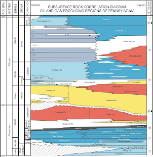
The Tuscarora and Rose Hill formations are Silurian in age and range from the Llandovery to Wenlock epochs (Telychian to Sheinwoodian stages). The particular moment in time that this cut represents is the very latest Telychian stage. Below is a stratigraphic chart from the PA Geological Survey website HERE.


In comparison to other Silurian localities I've collected at, the Waldron Shale is about the same age as the Rochester shale of New York and they are considered to be Sheinwoodian in age; The Irondequoit limestone underlies the Rochester shale and is just above the Rose Hill shales in the Sheinwoodian stage; The Keyser formation is at the very top of the Silurian grading into the Devonian.

Sunday, March 25, 2012

The Penn Dixie Paleontological and Outdoor Education Center

If you are a fossil collector, then Buffalo, NY is a great place to visit. Forget the Niagara Falls, there are so many roadcuts and creek beds to explore nearby! One of the best places to visit and collect is at the Penn Dixie Paleontological and Outdoor Education Center. This is an open, relatively flat area where many layers of the Moscow formation are exposed at the surface of an old gravel pit. The Hamburg Natural History Society runs and maintains the site as a natural and paleontological resource. Anyone can come and collect fossils there and it's safe for all ages since there are no steep walls.

Here is a panorama of the site (click to make it larger):


The geology exposed has been studied and charted by the club to produce this stratigraphic view:

The diagram has an exaggerated elevation so that more details about the layers can be illustrated but what it does show is how the layers dip gently to the southeast. The southernmost parts of the site, near the asphalt walkway above, have the youngest layers.

Most of the digging on site is focused on the "Smoke Creek Trilobite Bed" where Phacops and Greenops trilobites are fairly common.  The club maintains the site and occasionally will come in with a bulldozer to clear spent rock and expose more of the desired layers. Here is a group working the trilobite bed:


Any of the rocks lying on the ground in the above picture could hold a trilobite. If you don't want to work the exposed layers then you can take a turn at cracking the debris pile.

Just below the trilobite bed is the Tichenor limestone which is a very hard and resistance layer. You can find outcroppings of the layer near the northeast corner of the site where the water drains off.


The water has carved some deep channels which look like miniature canyons.


You can easily spend a few hours at any one point on the site exploring the many exposed layers and fossil zones. Some of the fossils I've found at the site are: Ambocoelia, Athyris, Emanuella, Mediospirifer, Mucrospirifer, Pseudoatrypa, Rhipidomella, Spinatrypa, Megastrophia, Phacops, Greenops, Amplexiphyllum, Aulocystis, Stereolasma.

Wednesday, December 28, 2011

Roseburg Quarry

Over the Thanksgiving holiday I had the chance to do some exploring of borrow pits and quarries north of Harrisburg. One of the sites I visited was a borrow pit near Roseburg, PA. I actually passed it while headed somewhere else but turned around to see if it had anything good.

Here is a picture of the pit facing north. You can see that there is a gentle slope to the rock and it actually dips to the southeast (right side of the picture).


Here are a couple of the more common fossils that I found

A large Rhipidomella penelope brachiopod


A flattened Bembexia gastropod


Some fossil "hash"


I did find some other fossils there that were new finds for me from PA and from the area that I will detail in subsequent posts.

I suspected that the rock was part of the Hamilton group and more specifically the Mahantango formation and I was right. However what surprised me was that when I looked at the geologic map most of the quarry is shown to be part of the Trimmers Rock formation which is upper Devonian and part of the Chemung group.

Here is a stratigraphic diagram of the Devonian rocks in Pennsylvania from the PA Geological Survey website HERE.


Here is a screen capture of the local geology of the pit from Google Earth. I am using the geologic map overlay available from the USGS website HERE.


The orange color represents the Mahantango formation and the green color is the Trimmers Rock formation. The main areas I was exploring were on the northeast side to the central part of the pit although most of the fossils seemed to be in the layers that were on the bottom of the pit. This map together with the dip of the rocks and my knowledge of local stratigraphy tells me that the layers in the bottom of the pit are most likely from the Mahantango formation while the top most layers are from the Trimmers Rock formation. That still doesn't tell me for sure where the fossils I found in the gravel piles that were pushed around came from but I'm fairly confident they are from the Mahantango.

Below is a wider geologic map view to put the regional geology into perspective. The layers I was exploring are on the outer edge of a large synclinorium (the Minersville Synclinorium) that has Mississippian rocks at it's center (actually Pennsylvanian rocks outcrop farther to the northeast but Mississippian is the youngest visible in this picture). A synclinorium is a large group of layered rocks that generally bend downward into a relaxed "U" shape but has smaller folds within it that may bend into individual tighter anticlines ("A" shapes) and synclines ("U" shapes). Not far to the north and east the synclinorium bends up into an anticlinorium (the Tuscorora Anticlinorium) which exposes older rocks from the Ordovician. The thumbtack shows the general location of the pit.


This same pattern is repeated all over the ridge and valley providence that the Appalachian mountains compose. With the Google maps and my knowledge of the stratigraphy I am better able to look for other potential sites and have a good idea what to expect. So to bring it all back together, the pit has fossils from the Mahantango and possibly the Trimmers Rock formations. Also while the rock layers are only gently dipping there may have been some geologic effects visible in the fossils (as you'll read in subsequent posts).