Ordovician aged fossiliferous rock exposures are somewhat uncommon in Pennsylvania. Most of the exposed rocks are Devonian to Pennsylvanian with the rest buried underneath. Besides the, now closed and eliminated, Swatara Gap locality the next best area to collect Ordovician fossils is up near State College. There is a thick exposure of rock from the Reedsville formation down through the Loysburg formation along US322 at the Reedsville exit. Not all the rock is fossiliferous but parts of the Coburg and Nealmont formations are good to hunt in. The sequence is mostly Middle Ordovician and records a shallow sea that is gradually deepening and then being filled in with continental sediments during the Taconic Orogeny. This is seen by the sequential deposition of limestone followed by black shales and then sandstone.
Here is an aerial view of the area with geology overlaid....
...and the annotated version
The fossils that I found were in thin to medium thickness limestones which belonged to the Coburn formation.
Orthoconic nautiloid casts
Rafinesquina brachiopods
Cryptolithus trilobite cephalons
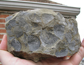
I think the fossil in the lower right is a Prasopora bryozoan
A cluster of what appears to be Dalmanella brachiopods
I think this is the underside of the very front most portion from an Isotelus cephalon.
Another unknown Trilobite bit
Another Bryozoan that is shown in cross section due to the way the rock broke.
The fossils above represent the material I picked up during a short visit to the roadcut along US 322 shown in the above photos. I didn't have a bag with me since I didn't expect to find anything so these are what I was able to carry in my arms and pockets. I'll likely visit this site again in the future.


Hello,
ReplyDeleteI was curious as to how you got the rock formation overlay on Google Earth.
Thanks!
Rob, Go to the USGS webpage: http://mrdata.usgs.gov/geology/state/ There you can download state geological maps and one of the options is as a .kmz/.kml which is what Google Earth uses.
Delete-Dave