The Ginkgo tree is another of the "living fossils" but it's surprisingly well known and familiar. You'll probably recognize them on city streets by the waxy, wide green leaf and by the fleshy, ping pong ball sized fruit with the large pit that smells like vomit.
Ginkgo trees are the national tree of China and typically have a leaf that is wide and fan shaped that drops in the winter, similar to deciduous trees. However, the leaves are very primitive with simple veins. Unlike most tree species common in the U.S., the Ginkgo is dioecious, meaning trees are male or female. Female ginkgoes produce seeds which are covered in a fleshy coating that contains butyric acid, also found in rancid butter, which is what gives it the nasty smell. For this reason some cites have removed the female trees or, in some extreme cases, all the trees because of complaints from the smell or the slippery conditions caused by the fruits pulp. It's a slow growing tree but very hardy and adapts to most temperate climates well. It is my favorite tree and I planted one in my backyard when I moved into my house.
Fossils of Ginkgo leaves are first found in the Jurassic period in sediments from central Asia. At least two species have been identified from this time but there were as many as five or six species identified in the Northern Hemisphere during the Cretaceous. After the KT extinction event, Ginkgoes seemed to go into decline around the world. In the Paleocene there was only one species left, Ginkgo adiantoides, and it is considered to be polymorphic (having many different looks). In this way it accounts for both the fan shaped leaves of Ginkgo adiantoides and the thin finger-like leaves of Ginkgo dissecta. By the late Miocene it had disappeared from North America and (5 million years later) Europe, retreating into China. There it persevered in marginal habitats until being discovered by humans. It was cultivated by Buddhist monks for generations until it started to be brought out into the wider world by 1100 AD. It spread back into Europe and America in the 1700's as plantings. Today you will often find the only living species, Ginkgo biloba, planted along streets in cities as decorative trees. They actually thrive in the polluted city air and tolerate the salt used to thaw ice in the winter and thus are a perfect fit. There are even some that survived the atomic bombing in Hiroshima! Finally, Ginkgo biloba reputedly has medicinal value and is marketed as being good for memory and the seeds are used in some traditional Chinese and Japanese foods.
Here are some modern leaves from my backyard Ginkgo biloba tree. Notice the differences in the shape and "lobes" of the leaves.
You can see that the leaves that are "split" or "lobed" are typically at the very ends of the branches.
In fact the most typical fan shaped leaves are found closer to the trunk on my tree. There are some exceptions of course:
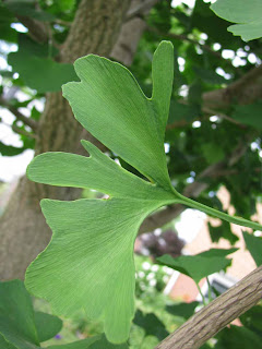
After seeing these examples on my single tree I more readily accept the theory that Ginkgo biloba and the thin finger-like leaves of Ginkgo dissecta likely came from the same tree, but from different parts.
Onto the fossils! This is a Ginkgo adiantoides from the Paleocene aged Sentinel Butte formation of North Dakota.
And this is a Ginkgo dissecta from the Eocene aged Tranquille shale in British Columbia, Canada
For more info about Ginkgos, check out the Paleobotany.org website
Another great page with lots of pics and even some fossil wood: The Ginkgo Pages
There is a Ginkgo Petrified Forest in Washington State.
Pages
▼
Tuesday, August 31, 2010
Sunday, August 29, 2010
"Blue Forest"
The Blue Forest is an area in the Eden Valley region of Wyoming where spectacularly preserved petrified wood can be found. The directions to get there are a bit winding and once you get there you may be a little confused by the relatively flat terrain.
View of the area
It's called the Blue Forest because the fossils are often preserved with a ring of blue chalcedony around a gray/black opal replaced fossil wood. You can see piles of dirt and the holes the came from all over the nearby area. You can search the surface and dirt/rock piles for shards of discarded fossil wood/agate but to find whole branches or trunks of wood you have to dig into the rock layers beneath your feet.
A typical trench/hole:
Millions of years ago this area was a seasonal swamp that was part of the ancient Lake Gosiute. Logs and branches would fall into the water and sink to the bottom but were not always quickly buried. The wood became waterlogged and algae would grow on the surface forming Stromatolite like coatings. Eventually both the algae and wood were buried and became replaced with Silica percolating through the ground water. When you are digging you'll find the Stromatolite layers first but you don't know how big a piece of wood you've found yet because the layers thickness can vary.
Here you can see thick layers of Stromatolite that built up on a thin branch.
Experience will help you determine how best to dig out the fossils and how thick a piece of wood you have under all the layers of Stromatolite. Once you get the fossils out of the ground they will cut and polish very nicely since it's agate.
I've not stayed at the site of the Blue Forest long enough to try my had at extensive digging but here is a picture of some pieces of wood I found on the surface.
View of the area
It's called the Blue Forest because the fossils are often preserved with a ring of blue chalcedony around a gray/black opal replaced fossil wood. You can see piles of dirt and the holes the came from all over the nearby area. You can search the surface and dirt/rock piles for shards of discarded fossil wood/agate but to find whole branches or trunks of wood you have to dig into the rock layers beneath your feet.
A typical trench/hole:
Millions of years ago this area was a seasonal swamp that was part of the ancient Lake Gosiute. Logs and branches would fall into the water and sink to the bottom but were not always quickly buried. The wood became waterlogged and algae would grow on the surface forming Stromatolite like coatings. Eventually both the algae and wood were buried and became replaced with Silica percolating through the ground water. When you are digging you'll find the Stromatolite layers first but you don't know how big a piece of wood you've found yet because the layers thickness can vary.
Here you can see thick layers of Stromatolite that built up on a thin branch.
Experience will help you determine how best to dig out the fossils and how thick a piece of wood you have under all the layers of Stromatolite. Once you get the fossils out of the ground they will cut and polish very nicely since it's agate.
I've not stayed at the site of the Blue Forest long enough to try my had at extensive digging but here is a picture of some pieces of wood I found on the surface.
Friday, August 27, 2010
"Turritella Agate"
"Turritella Agate" is a well known and popular stone that is composed of the fossil shells of a high spired snail called Elimia tenera. The name Turritella is given to the fossils because it looks similar to that family of gastropods, but they are confined to salt water whereas these snails lived in fresh water. The agate itself is considered to be a slightly to completely chalcedonized coquinite.
Here is a polished piece:
The rock formed along the edge of ancient Lake Gosiute and is part of the Green River formation. The accumulations of all these shells must represent a very productive ecosystem and is known to occur in several different stratigraphic horizons within the formation.
I had the opportunity to collect some of the rough stone during a trip a few years back. The best area to collect is south of Wamsutter, WY along the rim of a regional cliff system.
There are lots of small pieces scattered around that are perfect for kids or specimen hunting.
Some of the individual snail shells have weathered out and are available for surface picking.
The material that makes for the best displays has the snail shells oriented parallel to the display surface like in the first polished picture or the field picture below of a rough specimen.
If you cut the rock perpendicular to the shells, this is the view you are likely to get:
The trip to the site was fun and full of nice badland like scenery. A visit can be accomplished with only an hour or so drive from Interstate 80 and makes for a good rest stop when crossing Wyoming either to or from Kemmerer.
Wednesday, August 25, 2010
Parachute Creek member of the Green River Fm.
The Green River formation is an expansive group of rocks which all were lain down by a series of ancient lakes in the Eocene era of the Paleogene period. As you can see by the map below, the deposits that exist today are extensive.
The formation is really four interconnected basins from two major lakes called Lake Unita and Lake Gosiute. The best know parts of the formation are those from Wyoming around Kemmerer where the fossil fish are quarried from the sediments of former Lake Gosiute. To the south in Colorado and Utah, fossil Lake Unita left a similar record but the rock type is a little different. In Wyoming, the fossils are generally preserved in a freshwater limestone while in Colorado and Utah the rocks are oil shale. Both lakes had similar flora and fauna and record a sub tropical ecosystem.
One of the most accessible and well know sites to collect from the Lake Unita oil shales is at an FAA radar dome near Douglas Pass. Here the rocks are considered part of the Piceance Creek basin and the most collectible shales are found in the Parachute Creek member. They are exposed as thick bedded near horizontal layers of light gray shale. The fossil finding process involves taking a piece of the shale and splitting it parallel to the plane of fossilization. The layers are very thin and it's not easy to split the rock completely on a single plane. Often you wind up breaking off a spall and you hope you find something. Unweathered rock is light to dark brown, due to the hydrocarbon content, and the preservation is quite good with thin black carbon films that contrast well against the host rock.
I've had some success collecting at this site over the years and it is a favorite of mine. Here are some pictures of specimens from my collection:
Insects
Plants
I got lucky once and found both halves of a bird feather. The detail is superb and you can see color bands as well as the texture of the feather itself. Bird feather fossils are rare but not uncommon from the Parachute Creek member.
For more info on the Green River formation, check out this page at the Fossil Museum.
Or you can go the the University of California's Museum of Paleontology website and read their page.
Monday, August 23, 2010
More Green River
In a previous post I mentioned how my Grandparents carted me all over Colorado to look for fossils and minerals. One of the places they took me was to Grand Junction so that I could explore the Parachute Creek member of the Green River formation. One of the best known localities to access this member is at Douglass Pass which is about 40 miles north as the crow files from Grand Junction, CO. Once you reach the pass you still have another 5 miles of dirt and gravel road to drive to get to an FAA Radar Dome where the rock layer is exposed on the side of a mountain. On the way up the gravel road you pass by many exposed layers of rock which are part of the Green River formation but are not the most productive layers. Since the Green River formation is a lake deposit you get different characteristics of rocks depending on how big the lake was at the time and the environment. My grandparents patiently stopped and waited at one of these road cuts as I scrambled up and down the slope looking for fossils and amazingly I actually found some:
A thin, sandy horizon of rock had fallen from some part of the cut and it had some fossil fish scales and bones on it. Below is a fish vertebrate (I think) and some scales that were on one piece of rock.
I don't know what kind of fish these fossil are from but the age is Eocene and must have been in a shallow deltaic environment for the sandy rock layer to form. I've been back several times in recent years but have not been able to locate any more pieces like those shown above nor the layer that produced them.
Saturday, August 21, 2010
First trip to Green River
I’ve been fortunate that my Mother’s parents lived in Boulder, Colorado as I has allowed me many opportunities to visit them and also get some mineral and fossil collecting done. During a trip in 1996 they drove me all over the state to look for stuff including to Florissant, CO for fossils and a Topaz mine, Grand Junction, CO to the Parachute Creek shale and clear up to Kemmerer for fish fossils in the Green River formation. This was to be my first trip to the Kemmerer and I’d picked one of the many quarries that were advertised in “Rock and Gem” magazine to go visit. I really wish I could remember which one I went to but all I remember is the long drive back to the quarry on a badly rutted dirt road. My Grandfather was driving and we were riding in a regular car that did not have much clearance. I distinctly recall hearing the bottom of the car scrape the tops of some of the higher bumps along the way but we made it without incident.
There were a half dozen other people there waiting for the quarry to open which it did shortly after we arrived. The quarry foreman explained what to do and where to go and I eagerly set to work picking a nice area where the rock seemed to be jutting out from a low wall. I don’t have many pictures of the quarry itself as this was back before digital cameras were cheap so all I had was a film camera. The best picture I have is this one of my Grandfather watching me try to split a slab.
He was a great guy who wanted to see his grandson find some good fossil fish and made sure that anything I did find was moved out of the working area while giving advice on where to split. The trip was in late September so the weather was not particularly warm as you can see by our clothes.
I had visions in my head of large pristine fossil fish with every blow of the hammer and scan of the subsequent splits. The quarry foreman had explained the concept of the “split fish” layer to me but it took a couple of fish finds for me to understand exactly what he meant. The “split fish” layer is self descriptive in that the fossils will split with the layers of rock so that you often get a little bit of a whole fish on the facing sides of a split slab. You can see an example of what I mean below:
After four hours of me splitting and my grandparents watching admiringly our time was up. I had found a number of Knightia and Diplomystus and I’d nicknamed the strata we were splitting as the “Explodofish” layers since so many of the fish I’d found showed evidence of post mortem gas expulsions with scattered scales or bones.
I did find two partial Priscacara and the first would have been very large but I only found half of it in many pieces.
The other was a whole fish but didn’t split well so that I have some bones but the rest is just impression. It’s too bad I didn’t know about how this specimen could have been salvaged by gluing the covering split back in place and then prepping the fish through the rock so that it appeared whole.
I also found some Phareodus scales and a partial jaw with teeth.
That evening we stayed at a local motel which was an adventure in and of itself. We checked in and went to our room where the door was already hanging open a little. After checking to make sure no one was in there and they motel had not double booked the room we entered into what we could only call a decorating nightmare. The walls and ceiling were painted white except for one wall which was dark purple. Before the paint had dried the workers had apparently sprayed glitter all over the place. The toilet had a constant drip and there was a hole in the floor near the base. To top it all off there was a velvet painting of the Virgin Mary above one of the beds. We were all grateful that the lights indeed turned off as we didn’t have to stare at the décor anymore and we checked out first thing the next morning. All in all it was a great trip and I enjoyed spending time with my grandparents.
A last couple of specimens that I've kept more for the memories than for the quality.
Thursday, August 19, 2010
The Green River Formation
I'm going to do a series of posts over the next week that will focus on the famous Green River formation. I wanted to give some background first so that you, the reader, would have some idea of the places and names I'm referring to.
The Green River formation is probably best known from deposits near Kemmerer, WY that produce superb fresh water fish fossils. The formation itself is vast and covers three states (Wyoming, Utah, Colorado) and represents three distinct lakes that existed for a very short, geologically speaking, time during the Eocene epoch (58-38 MYA).
The deposits in Wyoming are from two ancient lakes. The smallest is called Fossil Lake and the the primary producer of the fish fossils. Lake Gosiute is the larger lake and was confined to an area from Kemmerer east to Rawlins and from the Wyoming/Colorado border north to the Wind River mountain range. Lake Unita was the third and longest lasting of the ancient lakes and covered a region of Utah and Colorado from Provo, UT east to Meeker, CO and south to Grand Junction, CO. Lake Unita's deposits are often in the form of an oil shale and are finer grained than those of Fossil lake or lake Gosiute.
Here is a series of rough maps that show the approximate geographic extent of each lake through time.
This is a stratigraphic view of the lakes through time and geography.
This is a map of the current geographic extent of the rock deposits derived from the lakes.
During the Eocene the lakes existed in low lying areas within a wet, subtropical environment but since then they have been elevated many thousands of feet above sea level and are mostly in a high desert environment.
I've had the opportunity to collect from, and will detail more in the next few posts, the Fossil Lake deposits at Kemmerer, Lake Gosiute deposits at the "Blue Forest" and Wamsutter as well as the Douglass Pass deposits of Lake Unita.
This last chart is one which correlates the many geographically distant deposits with each other.
The illustrations used in this post are all from the book "Paleontology of the Green River Formation, with a Review of the Fish Fauna" by Lance Grande and was published as Bulliten 63 by the Geological Survey of Wyoming. This is a most excellent resource and, while it focuses more on the Fossil Lake fauna, I highly recommend it to anyone who wants to learn more about the Green River formation.